Backpacking in Haleakala Crater on Maui

Jinger Hiking in Haleakala

Out of the hundreds of thousands of people who visit Haleakala National Park on Maui, only a small percentage will hike in the crater and stay a couple days. Be one of the lucky ones who do. You will venture into a desert-like landscape sculpted by the volcano and wander through colorful cinder cones and lava fields.

Haleakala means “House of the Sun.” Its summit rises 10,023 feet. Watching a sunrise is popular from up top and many people who visit get up before dawn to catch it.  Little do they know that there is a lot more to Haleakala than a beautiful sunrise.

Sunrise at Haleakala

The day before your trek, check in at Park Headquarters to pick up your permit for tent camping. Cabins are available; however you must reserve them in advance.  Call the headquarters for details.

On the first day, park at the Halemau`u trailhead, then hitch a ride up to the top. There is a designated area for hitchhikers next to the lot. Your journey begins at the Sliding Sands trailhead next to the Visitor Center. The hike down is fairly easy and the scenery is spectacular. It did not take long for my husband and I to feel remote and far away from bustling crowds.

Lava Field in Haleakala

Silverswords dot the sides of the trail and grow to about 6 feet. These unique plants are indigenous to the crater and are protected. Even though they can withstand the harsh environment of Haleakala, they are quite fragile. Look, but don’t touch.

Silversword

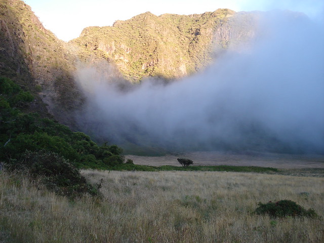
Paliku is the first campsite, about 9 miles into the crater.  The elevation change is about 2500 feet lower so you will see more vegetation. After setting up camp we were amazed by watching mist drop from the side of the steep cliffs as if it were poured into the crater. As the sun dipped below the horizon, the night sky was illuminated by brilliant stars.  With no artificial lights around, our eyes adjusted to the darkness easily and we saw more stars than we could imagine.

Paliku in Haleakala Crater

The next morning’s sunrise was spectacular. The second day of hiking is a gradual 6 mile climb back up through lava fields on the Halemau`u trail. You’ll wind between more vibrantly colored cinder cones with shades of red and orange. The next campsite is Holua. We set up our tent just as a storm rolled in. It reminded us of how fast the weather can change out here.

Cinder Cone in Haleakala

On day three we caught another amazing sunrise before packing up.  The hike out is about 3.8 miles.  It starts out flat at first, then quickly steepens as you switchback several times up the cliff.  Pause for a moment and look back at the majestic valley below.  Your hike ends at the Halamau`u trailhead and back to your car.

Holua Valley in Haleakala

This was first posted on Cheapoair.com (offering cheap tickets), where I guest blogged.

Rattlesnake Mountain, Snoqualmie Pass

Rattlesnake Mountain has three exposed ledges overlooking Rattlesnake Lake and has spectacular views of the Snoqualmie Valley on a clear day, one of which we lucked out on.

The hike up to the first ledge winds through the forest with many switchbacks for 2 miles.  It was a good workout and we warmed up quickly.  The view from the first ledge was unbelievable and I can understand why it’s so popular.  Since this cliff is steep, you have to be careful and not to lose your footing.  It was pretty crowded when we got there and only stayed a minute.

We kept hiking and ten minutes later were at the next ledge, with no one else.  We continued on for another ten minutes to the third ledge and it was even more peaceful and beautiful.

We opted to follow the trail onward to East Peak on Rattlesnake Mountain.  We hiked through thicker forest and saw so many different types of mushrooms.  Here are just a couple:

We got to East Peak in less than two hours from Rattlesnake Lake.  We took a break and enjoyed the view of Mount Si to the north.  Our total round trip hike was roughly 9 miles.  If you want to check it out, drive east of Seattle on I-90 to exit 32.  Take a right at the stop sign and follow it to Rattlesnake Lake Recreation Area.

Mystical Mount Rainier

DSC04199

 The unpredictable weather on Mount Rainier did not stop us from making the drive from Seattle for a hike.  We knew it was only a matter of time before all the wildflowers would be covered with snow.  Once we got to Paradise Visitors Center at Mount Rainier National Park, the fog was very thick.

Quite different from when we visited on the 4th of July.  Back then we stomped up the snow filled hill unaware that a trail lay about 10 feet beneath us.  See the difference? Rainier July vs Oct 2011 copy

This time, on the first of October, the snow had melted and flowers were in bloom.  Even with the thick and gloomy fog, the wildflowers were vibrant.  Wildflowers

We hiked above the tree line and we found a clearing in the fog, which made us feel as if we were sandwiched between two clouds.  The break revealed some glaciers and a waterfall in the distance only for a few minutes before getting socked in again.

Glacier

It’s amazing how volatile the weather is up on the mountain, which gives it plenty of personality.  Make sure to be prepared for any conditions when visiting Mount Rainier National Park.

Rewarding Break at an Alpine Lake

Mason Lake

Mason LakeFinding a hike up to an alpine lake in the Cascades is like finding a brewery in Seattle. There are plenty of them and for the most part refreshingly good!

Even though there are so many hikes to choose from, it can be tough depending on the trail selected. The reward is usually sweet since there are fewer crowds willing to make the trek.

We recently hiked up the Ira Spring Trail to Mason Lake. It is about 7 miles round trip. The trail starts with a gradual incline which turns into a steeper grade after roughly a mile. Mount Rainier peeks out from behind the mountains in the distance. The higher we hiked, the more Rainier revealed itself at viewpoints.

Mount Rainier

At 2.8 miles, we approached a trail junction directing us to Mason Lake. The other direction would have taken us up Bandera Mountain. We hiked that route in the beginning of July and the top was covered in snow. Back then Mason Lake was frozen over too. Here’s what it looked like then:

Mason Lake frozen over

After an hour and a half from the trailhead, we made it to the lake. A group of rocks on the shore became a perfect spot to take a break. The crystal clear water looked inviting, so we took a dip. Let’s just say that the lake was crisp and invigorating. We hopped out of the water quicker than we jumped in. Then sunned ourselves on the rocks.

Mason Lake

This is a great hike on a hot and sunny day. The views are worth it and there are many routes you can choose from while in the area. If you want to find an alpine lake near you in Washington, check out the WTA website.

About JingerVentures

Venturing through the Bryce Canyon spires

One of my goals in life is to venture into every corner of this amazing world.  The thing is there are no corners, so my search is endless!

Come along with me as I dive in and completely explore  my surroundings.

Got any suggestions on new places I should visit? Send them my way.  I love taking on new adventures whether it’s down the street or across the globe.

If you know of a hidden gem I should get out and see, let me know by leaving a comment here or send me an email at jingerventures@gmail.com.